

Paul Taylor
Independent Artist
On the afternoon of November 10, 2012, I walked the length of Taylor Street in San Francisco without looking up from my smartphone. During the 2.2 mile hike, I followed my position on Google Maps, listened to music through earbud headphones, and tweeted my progress at each intersection. I recorded various data with a GPS tracking app. Dressed in a blaze orange jumpsuit I wore a foam helmet that restricted my vision to the phone in my hand (fig 1). Collaborators were stationed at every corner. When they saw me approach, they called me and talked me safely across the street.

Fig 1. Digital Trust Hike 1, 2012, Paul Taylor, documentation of a performance, © Paul Taylor
Conceptually, the Digital Trust Hike falls into traditions of both ambulatory art practice and locative media projects. Walking-based performances of the past, specifically those conducted by Richard Long, Francis Alÿs, and Yayoi Kusama, contributed to my process, especially with regard to strategies of documentation. I will explore these connections in greater detail when I discuss the translation of my performance into a visual format.
While the Digital Trust Hike could be considered a locative media project, it deviates somewhat from the way such projects are typically organized. When I think of locative media I imagine work in which an artist or team of artists have created location specific content, accessible by participants via some type of mobile device, with the goal of enriching and expanding the participants’ experience of a particular place. For example, the artist team Plan B (Sophia New and Daniel Belasco Rogers), in their 2008 work Departures, created a guided tour of the Leipzig airport facilitated by special luggage carts [1]. In my performance, this hierarchy was upended. As the subject of my experiment, I was dependent upon the information provided to me by my collaborators. This information was necessarily provided to me in real time so that I could synchronize my movement to my environment, maintaining my personal safety.
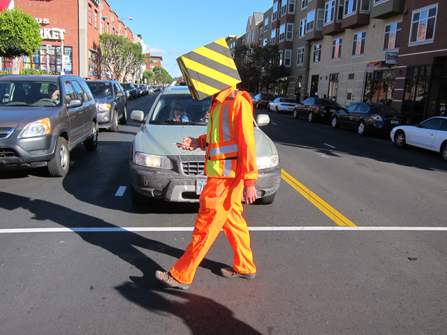
Fig 2. Digital Trust Hike 2, 2012, Paul Taylor, documentation of a performance, © Paul Taylor
While conscious of my project’s connections to other work, my main impetus for conducting the hike was personal. When I moved to San Francisco, I bought my first smartphone, an Apple iPhone 4. As I began to rely on my phone for basic navigation, I became both concerned and curious about the effect this dependence was having on my experience of walking in the city. Moreover, I started to think about the various networks involved in digitally mediated movement. The Digital Trust Hike was a way to explore and illustrate various networks’ effects on my travel through an urban environment.
During my performance I used Google Maps to orient myself. While running this application I relied on several different networks to determine my position; satellites provided GPS data which were augmented by cell phone towers and local Wi-Fi signals [2]. As I followed my progress by tracking the flashing blue dot on my iPhone’s screen I could anticipate upcoming intersections. However, as I was attempting to replace my senses with phone applications, I was unable to depend on traffic lights and other visual inputs to safely cross the street. To overcome this self-imposed restriction I set up a network of collaborators. Prior to the hike, I reached out to personal contacts via Facebook and email, assigning them to intersections along my route. In so doing, I enlisted members of my social network to serve as safety sensors, mapping individuals from the internet – a community whose connections are not location-dependent – onto a specific urban setting. Communicating by phone (connected by cell tower), my collaborators told me when to wait, when to cross the street, and when to avoid various obstacles in my path. When they were not directly engaged in mediating my well being I encouraged my collaborators to document my progress by taking photographs or recording video with their phones.

Fig 3. Digital Trust Hike 3, 2012, Paul Taylor, documentation of a performance, © Paul Taylor

Fig 4. Digital Trust Hike 4, 2012, Paul Taylor, documentation of a performance, © Paul Taylor
This process of documentation was one of the ways in which I tried to visually interpret the various network interactions that facilitated my performance. I thought back to Yayoi Kusama’s Walking Piece from 1966, in which she traveled through New York City in a kimono. Photographer Eikoh Hosoe captured the contrast of her traditional Japanese attire against the backdrop of a gritty, highly urban setting [3]. I remembered one photo in particular of Kusama crossing the street. During my walk, dressed in orange and wearing a high-visibility foam helmet, I drew a somewhat similar contrast to the streets and passers-by of San Francisco. By receiving images from my collaborators in the days following the hike, I was able to relive my experience through their eyes, albeit in the fragmented way we generally consume imagery through the internet. Using my website and other social media, I rebroadcast documentation of the hike to a greater online community. A performance that was planned online and conducted in the “real world” was brought full-circle.
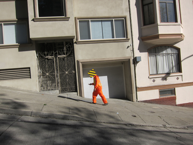
Fig 5. Digital Trust Hike 5, 2012, Paul Taylor, documentation of a performance, © Paul Taylor
My use of a GPS tracking application [4] during the hike allowed for another strategy in the visualization of my performance. Utilizing GPS data, the application created a route line for my walk. In a way, the route line was akin to the lines produced by Richard Long’s Line Made by Walking [5] or Francis Alÿs’s The Green Line [6]. However, unlike the lines resulting from Long’s and Alÿs’s actions, my route line manifested in a purely digital form. Its jagged contours illustrated the noise and inaccuracy inherent in GPS data when viewed in close-up [7].

Fig 6. Digital Trust Hike, GPS Route Line, 2012, Paul Taylor, screen shot of GPS route line, © Paul Taylor
The Digital Trust Hike presents the combination of several networks acting together to facilitate my navigation through an urban space. While I used hardware networks – satellites, Wi-Fi, cell phone towers – to track my location, ultimately I needed a different type of network to complete my performance. I put my trust in my collaborators, whose directions guided me safely through my hike.
Collaborators:
Sholeh Asgary
Christy Chan
Jen Cohen
Kyle Dunn
Rachelle Dunn
Evan DeSpelder
Julie Johnson
Jay Meindertsma
Andrea Nelson
Kirby Ortiz de Montellano
Lara Ortiz de Montellano
Maya Ortiz de Montellano
Paul Ortiz de Montellano
Alon Rohter
Adam Sharron
Victor Stevko
References
1. “Departures,” on Plan B’s official website, accessed February 4, 2014, http://planbperformance.net/index.php?id=departures
2. Fleishman, Glenn, “How the iPhone knows where you are,” Macworld, April 28, 2011. From Macworld’s official website, accessed January 11, 2014,
http://www.macworld.com/article/1159528/how_iphone_location_works.html
3. “Walking Piece,” by Yayoi Kusama, photographed by Eikoh Hosoe, on the Whitney Museum’s website, accessed February 4, 2014, http://whitneymuseum.tumblr.com/post/32471074463/for-her-1966-performance-walking-piece-yayoi
4. Ubermedia. (2012). Location Tracking GPS Kit Pro (version 3.7) [Mobile application software]. Retrieved from http://itunes.apple.com
5. “A Line Made by Walking,” on Richard Long’s official website, accessed December 18, 2013, http://www.richardlong.org/
6. “The Green Line,” on Francis Alÿs’ official website, accessed December 18, 2013,
http://www.francisalys.com/
7. I should point out that I briefly went off course at the intersection of Chestnut and Taylor Streets and Columbus Avenue. I realized this by tracking my position on Google Maps and alerted my collaborator, who had become confused by the three-way intersection.
Bio
Paul Taylor is a multimedia artist based in the San Francisco Bay area. His work explores the effects of increased digital immersion on our perceptions of – and interactions with – our surroundings and with each other, and has shown his work in exhibitions and screenings throughout the United States and abroad, including: Munch Gallery, New York City; Headlands Center for the Arts, Sausalito, California; Videoholica 2012, Varna, Bulgaria; Video Art Festival Miden, Kalamata, Greece; MINA International Mobile Films Screening, Wellington and Auckland, New Zealand. Paul was the recipient of the Headlands Center for the Arts Graduate Fellowship award in 2011. He received his MFA in visual art from the University of California, Davis.
www.disruptedstructure.com