

Brooke Belisle
American Council of Learned Societies New Faculty Fellow, Stony Brook University, New York
I: Introduction: We’ve been here before
In his 2011 State of the Union address President Obama declared “This is our generation’s Sputnik moment,” a crossroads in history where we decide either to “win the future” or to lose it. [1] Obama recalled that, “Half a century ago, when the Soviets beat us into space with the launch of a satellite called Sputnik, we had no idea how we would beat them to the moon. The science wasn’t even there yet. NASA didn’t exist.” But, he argued, with our efforts in the ensuing space race, “we didn’t just surpass the Soviets; we unleashed a wave of innovation that created new industries” and transformed the country. He argued that this kind of technological innovation defines the United States: “We’re the nation that put cars in driveways and computers in offices; the nation of Edison and the Wright brothers; of Google and Facebook.” By pointing to digital media companies, and suggesting that the current industry of information technology came out of the space race fifty-years ago, Obama called for a ‘next wave’ of technological innovation. This “Sputnik moment” would have to shoot for a new moon.
Speaking at the Kennedy Space Center in 2010, Obama had to explain why he was defunding NASA and reneging on President Bush’s plans to send astronauts on another moon mission. He recalled the 1969 moon landing with nostalgic patriotism, claiming “the space program has always captured an essential part of what it means to be an American –– reaching for new heights, stretching beyond what previously did not seem possible.” [2] He insisted, however, that we consider the moon landing “only the beginning,” and asked why we would want to go back when “we’ve been there before.” He proposed a new plan to land on an asteroid, and then, to go to Mars. The audience applauded but astrophysicists raised eyebrows. [3]
The need to imagine new innovations and further horizons, new races toward a new future, appeared at a moment when the Earth seems more consolidated and hemmed in then ever before. In the second decade of the new millenium, with global climate change, the global financial crisis, global epidemics, global corporations, global media, global trade policies, and global wars, the world appears almost claustrophobically coordinated. This coordination is largely enabled by the global infrastructure contemporary technologies produce and the global perspectives they seem to enable. In particular, the correlated rise of digital technology and remote sensing, both of which developed through the space race, has given rise to a global network of satellites, and this network, although largely invisible, thoroughly underwrites the structure of contemporary life. The desire for expanded American horizons appears as thousands of satellites, a majority of which are operated by the United States, weave a net of surveillance around the planet. [4] It’s not just that we’ve been to the moon before, but that we are, in a sense, still there. Our contemporary view of the world is actually and conceptually constituted, to a great extent, from the vantage point of satellites in orbit around our planet.
At the same time the United States stoked public desire to go to the moon, and began the space program, it also created the National Reconnaissance Office and began a military spy satellite program. Since the 1960’s, The United States has launched optical spy satellites under the codename Keyhole, a moniker well suited to the idea of peeking through an aperture that conceals the intimate distance of the voyeur. [5] The United States government did not admit the National Reconnaissance Office existed until 1992. The Keyhole satellite program was kept secret until 1995, when President Clinton released some details of its early years and declassified over 800,000 frames of early satellite images. By that time, satellites were becoming essential to the structure of contemporary life.
Today satellites underpin the global infrastructure of digital technology; they enable global media and telecommunications, monitor the weather, map geographic locations, relay telecommunication signals, survey the universe, and photograph the surface of the earth. Since the cold war, the United Sates military has relied on the control of information and extended agency that its satellites offer; but, in the twenty-first century, satellites have come to dominate warfare. US satellites transmit real-time images and dimensional maps that support operations in foreign terrain and expose foreign resources, facilities, and movements. They transmit orders from US commanders to troops while intercepting and jamming foreign communication signals. They enable precise navigation, automated weapons guidance, and the remote operation of drones. In 2003, satellite images were used as grounds for war when Colin Powell, U.S. Secretaty of State, presented what he called “photos taken by satellites” as visual evidence of “weapons of mass destruction.” [6] To the degree that digital satellites seem to directly picture the Earth as a globe, they conceal a visual regime that would assert the global as a particular way of picturing the world: a ‘global perspective’ put forth less as a politically and technologically mediated representation than as a real, objective, and transparent manifestation of the world itself.
If we are currently in another “Sputnik moment,” this correspondence calls out to historical relationships more complex than the narrative of progress Obama would tell. Hannah Arendt, writing in 1958, argued that Sputnik’s launch the previous year could only be understood by thinking back to Galileo’s telescope. [7] Bernard Stiegler, writing in 2010, argued that today’s GPS satellites must be understood in relationship with the historical mapping of the globe and the nineteenth century geological and geographical surveys that photographed the West. [8] The philosophical tradition in which Arendt and Stiegler are both situated has explored how changing correlations between the way the world seems to appear and particular coordinations of power may be negotiated at the level of human experience, reconfigured through perceptual and aesthetic practices that structure the production of knowledge. Today, satellite imaging articulates specific modes of seeing and knowing that subtend broader political, economic, and cultural frameworks.
The material presence of United States satellites in space, and how this presence enables colonizing forms of military power on Earth, is covered over by ideas of going to asteroids or Mars. In order to think about the contemporary visual regime structuring how both the past and the future appear, we need to think about the digital satellites currently mediating and constructing the horizon of a global present. The essay that follows will consider a series of contemporary artworks produced by Trevor Paglen that explores the forms of visibility and knowledge structured by surveillance satellites. Collectively titled The Other Night Sky, the images and installations in this series reframe our contemporary “Sputnik moment” through a correspondence of related historical moments, visual technologies, and ways of seeing. On the fiftieth anniversary of Sputnik’s launch, for example, Paglen made a photograph of the Moon whose title points to something else in orbit around our planet: LACROSSE/ONYX V Radar Imaging Reconnaissance Satellite Crossing the Disk of the Moon (USA 182), (2007). (fig. 1) In other images from this series, Paglen rearticulates iconic landscape photographs of the American West, revealing surveillance satellites moving through the skies of these familiar landscapes.

Fig. 1. LACROSSE/ONYX V Radar Imaging Reconnaissance Satellite Crossing the Disk of the Moon (USA 182), 2007, Trevor Paglen, C-Print 35 x 35 in, Copyright Trevor Paglen, Courtesy of the artist; Metro Pictures, New York; Altman Siegel, San Francisco; Galerie Thomas Zander, Cologne.
One image in Paglen’s The Other Night Sky series stands out because it does not show any man-made satellites, but, instead, pictures Jupiter as a bright dot in a dark sky, with its orbiting moons visible as smaller dots of light scattered around it. Titled After Galileo (Jupiter’s Moons) this photograph recalls Galileo’s discovery that what were thought to be fixed stars near Jupiter were actually moons in orbit around that planet—its satellites. Satellite moons are the ‘natural’ phenomena after which man-made satellites are named and modeled. The announcement of Jupiter’s satellite moons in The Starry Messenger in 1610 provided powerful evidence for the Copernican argument, offering new ways to read our bearings from the stars and helping bring a changed picture of the universe into view. [9] Like Galileo’s series of drawings made with the aid of a telescope, Paglen’s The Other Night Sky project also uses a blend of older and newer imaging technologies—in this case telescopes, cameras, and computers—to press what appears as the horizon of ‘direct’ perception. Paglen’s project also exposes that what may appear as stars are satellites. It reveals what is already there to be seen, but has largely gone unpictured. The Other Night Sky presents a visual technology and reality that hovers outside our awareness even as, and perhaps because, it so thoroughly surrounds and encloses us, so pervasively mediates and structures the way we see our world and imagine beyond it. [10]
II. The Other Night Sky: Experimental Geography
Describing himself as an “experimental geographer,” Trevor Paglen specializes in visualizing the otherwise invisible. [11] His work combines photography, digital computing, and strategies of cartography to track and document things that are deliberately obscure. [12] He uses the concept of geography to map not only spatial relationships, but also the material dimensions of political, economic, and cultural relationships. His book with A.C. Thompson, Torture Taxi, documents off-the-record flights used to illegally transport United States prisoners to off-the-map sites for interrogation. His series of photographs collectively titled Limit Telephotography uses telescopic lenses to picture military sites so off-limits that the government denies many of them exist. Paglen’s work is less about the images that result than the processes, actions, and politics required to produce the images. He visualizes things that might not be seeable until they are mapped—but this does not mean his maps explicitly render whatever they represent. As an aesthetic practice, “experimental geography” produces images between the register of the evidentiary and conceptual.
Paglen’s project The Other Night Sky uses techniques of astrophotography and digital computing to track and visualize spy satellites operated by the US government. This draws attention to objects in space that are not usually included in our idea, view, or images of the night sky. In 2008 Paglen exhibited parts of this series at the Berkeley Art Museum. (fig 2) Walking into the exhibit, the viewer was surrounded by twelve color photographs mounted at eye level along facing walls. These pictured grey or sky-blue backgrounds, with bright spots and streaks of stars. (fig 3) Their aesthetic and captions suggested scientific images of astronomical phenomena. But the “other” night sky pictured in these images included Earth-imaging satellites. By making visible the satellites that are, themselves, picturing our world, the The Other Night Sky project reveals that these satellites take place within the world they presume to picture. Positioning satellites within a rhetoric of scientific objectivity contests the evidentiary status often ascribed to images produced from satellites, showing how a satellite view is situated within the perceptual world rather anchoring any abstract vantage point whose view coincide with reality itself.

Fig. 2. The Other Night Sky / MATRIX 225, Trevor Paglen, June 1, 2008–September 14, 2008; Installation: UC Berkeley Art Museum and Pacific Film Archive (BAM/PFA). Photo Copyright Sibila Savage.

Fig. 3. KEYHOLE/ADVANCED CRYSTAL in Hercules (Optical Reconnaissance Satellite; USA 116), Trevor Paglen, 2008, C-print, 60 x 48 in., Copyright Trevor Paglen, Courtesy of the artist; Metro Pictures, New York; Altman Siegel, San Francisco; Galerie Thomas Zander, Cologne.

Fig. 4. KEYHOLE 12-3 (IMPROVED CRYSTAL)Optical Reconnaissance Satellite Near Scorpio (USA 129), Trevor Paglen, 2007, C-print 59 x 47 1/2 in., Copyright Trevor Paglen, Courtesy of the artist; Metro Pictures, New York; Altman Siegel, San Francisco; Galerie Thomas Zander, Cologne.
Unable to see what satellites are seeing, Paglen’s photographs can only expose the fact of the satellites’ existence, as they orbit around us as open secrets. Looking at one of the photographs in The Other Night Sky exhibit, the specificity of the caption, Keyhole 12-4 (advanced crystal) in Milky Way (USA 161), fails to decipher a cloudy cluster and swirl of light and shadow. The viewer searches for the imposter among specks and streaks of starlight. She cannot say which dot is the satellite, much less determine what distinguishes the Keyhole 12-4, from the Keyhole 12-3 mentioned in others photographs such as one that bears the caption: KEYHOLE 12-3 (IMPROVED CRYSTAL) Optical Reconnaissance Satellite Near Scorpio (USA 129), 2007. (fig. 4) A surveillance satellite appears in this photograph as a thin line tracing the satellite’s movement during the photograph’s exposure time. But, looking at this line, a view does not really know what the satellite “looks like,” or what it may mean, for instance, to be either “improved crystal” or “advanced crystal.” Parenthetical identifications such as “(USA 116)” and “(USA 129)” place these satellite within a national context and a numerical list but the ordering principle of the list is not apparent; we only know these are two of at least one hundred sixteen, unique and yet not singular. For someone familiar with satellite naming conventions, these caption name specific satellites. Keyhole 12-3, advanced crystal, (USA 116) is the one hundred-sixteenth spy satellite known to be operated by the United Sates, the third iteration of the twelfth generation of optical imaging satellites that use infrared sensors for night imaging. Using an insider, military argot, Paglen juxtaposes a visual inscrutability with administrative obfuscation, pointing past both the image and the caption to the hazy structures of power they may index but do not manifest.

Fig. 5. Active Military and Reconnaissance Satellites of the United States of America, 2008, Trevor Paglen. Installation: The Other Night Sky / MATRIX 225, June 1, 2008–September 14, 2008; UC Berkeley Art Museum and Pacific Film Archive (BAM/PFA). Photo: Sibila Savage.
Walking past the individual photographs in the exhibit, to the back of the exhibition space, the viewer passes behind a curtain into a dimly lit room. A large silk-screened globe hangs suspended in the center of the room, lit from within and slowly rotating. Four digital projectors placed around the room trace patterns of light across its surface. A brochure and wall text give the title Active Military and Reconnaissance Satellites of the United States of America and explain that each dot of light represents the real-time movements of one of 189 active US military surveillance satellites orbiting around the Earth. (fig. 5) Though it relies on and visualizes specific orbital data about specific satellites, the spectacle does not really reveal any information about the 189 satellites it references. The tiny projected spotlights render the Earth as the visual object these satellites orbit, the globe produced through their photographs. The viewer is interpellated by Paglen’s installation. She stands in the path of the projected lights, occupying an indeterminate position both identified with and set behind the satellites. The installation suggests how a digital, global image of the world may be produced and mediated by satellites, and how we may be complicit with this when we identify our point of view with the remove of an imagined satellite perspective.
Placed behind a curtain at the back of the exhibit, the globe seems to offer a multi-media finale to the show. As a three dimensional, moving, digital image representing all the satellites from a global perspective, it seems to exceed the still, framed, single-satellite photographs and stand as their summation. In fact, however, the algorithms visualized in the installation were developed first and enabled the photographs. In order to photograph secret surveillance satellites, Paglen first had to find them. His visualization required a surveillance project of its own. Photographing satellites whose existence and positions are classified by the United States government is made more difficult by the fact that each satellite is in orbit around a spinning planet. Paglen had to predict how the satellites moved to know where they would be and when they would be visible from specific vantage points. He gathered accounts of satellite sightings from amateurs around the world who photograph, identify, and discuss celestial phenomena with the help of digital sky atlases, astrophotographic software, programmable webcams, and online forums. He then worked with the digital artists and programmers at Eyebeam in New York to extract and identify patterns from this crowd-sourced database, creating software models predicting satellite movements and positions. The digital installation in the back room of The Other Night Sky exhibit brings these algorithms to life and visualizes the collective knowledge of a global network of satellite-watchers.
Paglen relied on computational models to find and to photograph the satellites, programming computer-guided cameras with telescopic lenses to capture them in visible phases of their orbits. Because long exposure times are necessary to concentrate light from distant objects, and different exposure times produce different depths of visibility, he had to know how far from Earth the satellite would be and how it would be moving while it was being photographed. He not only had to focus the camera in the right direction, at the right depth, at the right time, and for the right amount of time, but also had to program the camera’s movement relative the satellite’s orbital pattern and the Earth’s rotation during the exposure. He discovered the object he had photographed only when it appeared in the final image, tracing the path he had predicted. Relying on a virtualization in order to photograph a satellite’s actual appearance, Paglen derived its visual reality from its representation. The photographs seem to ground the digital installation in the final room of the exhibit, the evidentiary and documentary quality of photography itself constituting the satellites as verifiable referents for the installations’ moving dots of light; however, it is really the digital representation that authorizes and grounds the referentiality of the photographs. Rather than making a map and taking photographs to organize and represent something already visible, Paglen had to map what was otherwise invisible, and then make it visible by photographing it.
III. After Galileo
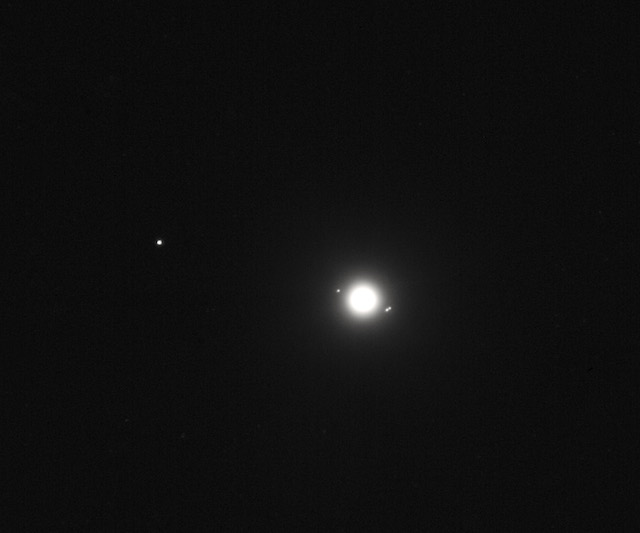
Fig. 6. After Galileo (Jupiter and Moons), 2008, Trevor Paglen, C-print 16 x 20 in. Copyright Trevor Paglen, Courtesy of the artist; Metro Pictures, New York; Altman Siegel, San Francisco; Galerie Thomas Zander, Cologne.
The Other Night Sky uses the most up-to-date resources of digital media to image the contemporary condition of digital satellite surveillance, but Paglen claims it was inspired by Kepler and the Copernican astronomers who used techniques of observation, analysis, and mapping to help expose the picture of an “other” night sky in the 17th century. [13 ] In order to extrapolate and digitally model the movement of satellites, Paglen used an approach that recalls Kepler’s mathematical analysis and modeling of planetary orbits. It also recalls Tycho Brahe, from whom Kepler inherited a series of detailed observations that helped him to derive principles predicting the position of Mars over time. Paglen relied on an existing set of observations in order to trace celestial objects, though his data set was not the work of one astronomer. Brahe discovered a new star, evidence resisting the notion that the universe was fixed and unchanging. Kepler re-mapped planetary orbits in elliptical paths that sketched a new picture of our solar system. [14] Paglen maps and visualizes satellites in orbit to expose the new objects that are themselves producing new pictures of the world and space.
Though Paglen’s method in The Other Night Sky may be more directly indebted to Kepler, he makes his debt to Galileo more visible with a an image in the series titled After Galileo (Jupiter and Moons) 2008. (fig. 6) The double valence of “after,” as both temporal and deferential, marks the distance and difference between Galileo’s visualization of the night sky and Paglen’s, while also suggesting one follows from and recalls the other. Galileo, like Kepler, took up and improved upon materials already at hand. He constructed a more powerful telescope and through it, saw further and more clearly. Over nights of careful observation, he realized four small fixed stars near Jupiter were actually moons moving around that planet as our moon orbits Earth, and this helped bring the Copernican universe into view. [15] While many arguments for heliocentrism were, like Kepler’s, demonstrated through abstruse mathematics, Galileo’s evidence was visible through a telescope. As telescopes proliferated, people could potentially see for themselves. By potentially distributing the picture of the universe among every seer, the telescope not only helped proliferate the Copernican insight, but also reiterated its political implications. The Copernican view asserted plurality as the very structure of the universe, replacing the singularity and consolidation of a stable center with the distribution of multiple, interrelated points of view.
After Galileo (Jupiter and Moons) could serve to picture the “the night sky” against which Paglen’s photographs present an “other night sky” now specked by digital satellites. It also suggests an echo between Galileo’s discovery of Jupiter’s satellite moons and Paglen’ exposure of satellites orbiting earth like secret moons. Most interestingly, however, it suggests a correlation between how Galileo and Paglen expose a new world view that has already emerged, but which the dominant structure of power works to resist and conceal. By exposing the man-made moons of surveillance satellites, Paglen exposes how a contemporary idea of the global is mediated by the very particular interests that conceal themselves in the production of images of the globe. He suggests that a tradition of technologically mediated efforts to see and map, that includes seventeenth century astronomers, might offer resources for our own technological and political moment.
The highly detailed digital sky atlases and advanced astrophotographic software that satellite imaging has made possible have also made it possible for even novice observers to photograph and identify celestial phenomena. While each secret surveillance satellite orbits around the planet, covertly photographing the Earth’s surface, feeding encrypted data to the government, thousands of individual observers on Earth are also witnessing and documenting the appearance of satellites in the night sky, uploading details and images to online networks of other observers. In contrast to the consolidation of visibility produced through satellites – which are largely controlled by state and corporate interests – self-directed networks of amateur observers collectively produce a way of seeing that opens through their multiple perspectives on the ground.
IV. Blank Spots on Maps
As “experimental geography” Paglen’s The Other Night Sky project takes place within, but also challenges, the history of seeing, surveying, and mapping. This history extends not only to include Galileo and Kepler, but the 17th and 18th century astronomers who established national meridians, and the nineteenth century astronomers who mapped the globe and charted the sky. Adding digital tools and computational methods to a telescope and photographic camera, Paglen suggests how specific visual technologies mediate aspirations of their own historical moment while also articulating the possibilities and problems of world-picturing across historical moments and through technological change.
In an essay for Artforum, Paglen considers The Other Night Sky in relationship to the mid-nineteenth century geographic and geological surveys that mapped the American West. He claims that “[i]deologically and technologically, today’s military and reconnaissance spacecraft are directly descended from the men who once roamed America’s deserts and mountains photographing blank spots on maps.” He sees his own “surveying and photographing of ‘the other night sky’ as yet another iteration of the frontier photographer’s tradition of visualizing and ordering blank spots on maps.” [16] In other words, Paglen aligns both contemporary spy satellites and his own work with these frontier photographers, suggesting he and the satellites are somehow up to the same thing. The story of those nineteenth-century photographers is not just about how the country was mapped and pictured but how it was produced by being made visible in very particular ways.
America’s organized efforts to map its own territory and natural resources began just before photography emerged, but they reached an apex when the wet-plate process and stereoscopic cameras enabled images whose scale, detail, and illusion of depth provided an unprecedented level of information and accuracy. For its “geographical and geological surveys” the United States government employed scientists and naturalists as well as photographers, including Carleton Watkins, William Henry Jackson, and Timothy O’Sullivan. The photographs were woven into the larger goal of information gathering, understood in coordination with the surveys’ other forms of documentation and overall goals. [17] Survey photographers often used large format cameras, capturing as big a picture as possible in order to express the relative features of a landscape. They also often used stereoscopic cameras, producing a pair of photographs whose relationship helped triangulate information about depth and measurements useful for geologists and cartographers.
Photographs by Watkins, Jackson, and O’Sullivan that were once categorized as government documents are now identified as artworks that not only helped create the aesthetic category of landscape photography also helped enable the categorization of photography as an art form. [18] Places photographed repeatedly in survey images have become iconic landmarks: El Capitan, Glacier Point, Mirror Lake, Cathedral Rock and Spires. (fig. 7) The dimensions expressed through these images seemed to express the scale of awe and shape of possibility that the West itself presented. [19] The romanticism and spiritualism with which these images were assimilated as portraits of the American West reappear in the way astronomical space is now portrayed through satellite imagery. [20] The frontier myth helps structure deep space as a landscape and order it as a series of places, while at the same time producing it as a symbol and idea. Data visualization becomes aestheticized, and awe-inspiring natural landscapes appear in space as dramatic twists and whorls. Sites are constructed as landmarks or points of interest, pictured repeatedly: Butterfly Nebula, Whirlpool Galaxy, Eagle Nebula and Spires. (fig.8).

Fig. 7. High Sierras and Tenaya Canyon from Glacier Point, Yosemite Valley, California, circa 1901-1906, William Henry Jackson, glass negative approximately 8 x 10 in., Library of Congress, Washington, D.C.

Fig. 8. Pillars of Creation or Gaseous Pillars in the Eagle Nebula M16, April 1, 1995 with the Hubble Space Telescope Wide Field and Planetary Camera 2, Photo No. STScI-PRC2003-34, Credit: Jeff Hester and Paul Scowen (Arizona State University), and NASA.
Paglen’s art practice may threaten to aestheticize digital imaging and data visualization, presenting information as already conceptual art in the same way frontier photographs and satellite imagery present the natural world as already beautiful imagery. With The Other Night Sky, Paglen exposes how satellites are complicit with a visual regime aligned with the United States military; they structure visibility in a way that would conceal their own material existence and the biases they materially embed and embody. The visual technologies used by United States military, however, from the photographic methods developed during early land surveys to the digital technologies developed in the space race, are the very same technologies Paglen uses. His network of surveyors, computational analysis, and telescopic cameras almost mirror the methods of the operations he investigates. Representing satellites in space using digital telescopes and computers would not disrupt the visual regime satellites instantiate. It might, in fact, bolster it by exposing remote sensing and digital technology as the most accurate modes of imaging even themselves.
Standing in the darkened back room of Paglen’s The Other Night Sky exhibit in Berkeley, watching digitally projected dots of light trace patterns on a suspended globe, a viewer may imagine she has acquired the point of view one step behind the vantage point of satellites. She is tempted to think this algorithmic representation compiles a planetary picture beyond the moon’s-eye-view of satellites, in which satellites themselves appear, a new spectacle of an expanded visual reality that she can survey, all at once, as an image she stands outside. But she stands within a space of visibility that both produces and is produced by the representation. The viewer’s own body is situated, like the globe, in a room whose walls are mounted with digital projectors. If she were to move her hand into the path of a projector’s beam, interrupting its light, dots of satellites would roam across her skin rather than roving the surface of the globe, leaping for a moment into new orbits.
IV. As I Photograph the Other Night Sky, the Other Night Sky Photographs Back
In 2010 Trevor Paglen published a book of his visual work, Invisible: Covert Operations and Classified Landscapes. [21] In it, he documents The Other Night Sky with an essay and photographs from the series, including many exhibited in the Berkeley show. In the book, however, a different dimension of the project emerges, with around half a dozen images in which stars and satellites appear within the sky of a specific landscape. These landscapes invoke iconic photographs from the nineteenth century surveys of the American West, and repeat some of their locations. Paglen’s photograph of Glacier point echoes, for example, view of Glacier point produced by Henry Jackson and Carleton Watkins. (fig. 9-12) Photographers such as Jackson and Watkins attempted to capture what they perceived as the dramatic and expanded dimensions of the American West with large-plate and stereographic formats. Their images expressed a sense of outsized possibility associated with the newest territories of one of the world’s newer nations.
Satellite imaging developed in the tradition of survey photography, using panoramic and stereoscopic strategies to picture the Earth from above but also new frontiers of astronomical space such as the lunar landscape. Paglen uses computer programs predicting satellite paths, and extended exposure times, to photograph a newer and even more expansive dimension of the American frontier opening from within the scenes of familiar Western landscapes. In his photograph of Glacier point, KEYHOLE IMPROVED CRYSTAL from Glacier Point (Optical Reconnaissance Satellite; USA 224), United States reconnaissance satellites are visible as slanted streaks of light cutting across curving trails of starlight in the sky above the rock.

Fig. 9. KEYHOLE IMPROVED CRYSTAL from Glacier Point (Optical Reconnaissance Satellite; USA 224), 2011, Trevor Paglen, C-print 30 x 43 in. Copyright Trevor Paglen, Courtesy of the artist; Metro Pictures, New York; Altman Siegel, San Francisco; Galerie Thomas Zander, Cologne.

Fig. 10. High Sierras and Tenaya Canyon from Glacier Point, Yosemite Valley, California, circa 1901-1906, William Henry Jackson, glass negative approximately 8×10 inches, Library of Congress, Washington, D.C., Identifier No. LC-DIG-det-4a06290

Fig. 11. Tasayac, or the Half Dome, from Glacier Point, circa 1865, Carleton Watkins, stereograph, Library of Congress, Reproduction No. LC-DIG-stereo-1s01436

Fig. 12. Half Dome 5000 ft. from Glacier Point, Yosemite, California, circa 1878-81, Carleton Watkins, mammoth glass negative approximately 18 x 21 inches, Courtesy of the Yale Collection of Western Americana, Beinecke Rare Book and Manuscript Library, Yale University, New Haven, Connecticut.
To open The Other Night Sky series in his 2010 book, Paglen chose a 2009 photograph titled DMSP 5B/F4 from Pyramid Lake Indian Reservation (Military Meteorological Satellite, 1973-054A). (fig. 13) A caption in the book describes a satellite launched in 1973 to aid war planning, that is now defunct but still in orbit, and presumably visible among the white streaks slanting from the photograph’s upper edge. The image recalls Timothy O’Sullivan’s well-known photograph, and lesser known stereograph, of Pyramid Lake, both of which he took in 1867, working for Clarence King on the geological survey of the fortieth parallel. (fig. 14) In O’Sullivan’s photograph, the rocky Tufa domes dominate the image, rising out of the water from the left foreground and receding toward the main pyramid. In Paglen’s reiteration, the sky dominates, and a small portable toilet stands in the left foreground. If photographers like O’Sullivan were, as Paglen has claimed, “filling in blank spots on maps,” then Paglen expands the map to include the sky, surveying its blank spots and filling in satellites that have appeared since these landscapes were first photographed. Rather than picturing satellites as “out of this world,” capturing them in images that visually echo the ungrounded views they produce of space, these photographs document satellites as features of the landscape. As a material object in our visible world, a satellite, a built, technical object, might appear as mundane as a portable toilet.

Fig. 13. DMSP 5B/F4 from Pyramid Lake Indian Reservation (Military Meteorological Satellite; 1973-054A), 2009, Trevor Paglen, C-Print, copyright Trevor
Paglen, Courtesy of the artist; Metro Pictures, New York; Altman Siegel, San Francisco; Galerie Thomas Zander, Cologne.

Fig. 14. Tufa Domes, Pyramid Lake, 1867, Timothy O’Sullivan (with King survey), albumen print from mammoth glass plate negative, Library of Congress, digital ID ppmsca.11875.
For photographs like that of Pyramid Lake, Paglen used a steady camera mount that did not track the movement of celestial objects or compensate for the Earth’s rotation. This kept features of the Earth’s surface stable in the image, while presenting stars and satellites as streaks of light traced across the sky. One image using a static mount, Nine Reconnaissance Satellites over the Sonora Pass (2008) (fig. 15) names a location whose landscape it does not picture. The Sonora Pass was a wagon trail from Nevada to California through the mountains of what is now Yellowstone Park. It was developed into a road after silver and gold brought new traffic in the 1860’s, and Josiah Whitney reported on it in his 1865 Geological Survey of California, helping gather information for a railroad line that was planned but never built. [22] Paglen’s photograph looks up to the sky above the pass, where new flows of traffic now take place.

Fig. 15. Nine Reconnaissance Satellites over the Sonora Pass, 2008, Trevor Paglen, C-Print 48 x 60 in., Copyright Trevor Paglen, Courtesy of the artist; Metro Pictures, New York; Altman Siegel, San Francisco; Galerie Thomas Zander, Cologne.
The long exposure time of Paglen’s Sonora Pass photograph traces the paths of orbiting stars and satellites relative to the Earth’s own orbit, resulting in a swirl of concentric circles. Expressing a redoubled movement, these dizzying marks also suggest a recursive visibility between the camera on Earth and satellite cameras in the sky. Paglen exposes that satellites are not the invisible sources of an all-encompassing view, but rather, that their view and ours are mutually structured. This rearticulates the implications of the Copernican insight: every viewing position is materially and ideologically situated; there is no stable position from which to directly survey everything else because every place is in motion relative every other place; every form of visibility articulates occlusions. Photographing satellites that are, themselves, engaged in efforts of visualization, Paglen does not quite say that satellites return our gaze. Rather he claims: “As I photograph the other night sky, the other night sky photographs back.” [23] In his formulation, one act of photography is met with another.
A relationship of potential reversibility seems to appear here: like photographs, celestial objects convey themselves to us only as images, as light. Photographs and stars articulate a structure of seeing that draws together disparate sites and temporalities; the image of a star and the image in a photograph make themselves visible as nothing but the light of one moment appearing in another. Rather than confirming that the appearance of reality itself follows a logic also inscribed into the geometry of optics or the mathematics of every new visual technology, we might take this is a suggestion that whatever we search for in the night sky could not appear as map or picture.
Positing the “other night sky” as both photograph and photographer shifts the emphasis in Paglen’s work from the objects that he pictures to the relationships of visibility that his work performs and exposes. His Other Night Sky photographs do not just document the facticity of secret satellites; they reveal how satellites exist as visible phenomena within larger relationships of visibility. Using long exposures, Paglen’s photographs show how satellites draw paths across the sky, etching their existence in traces of light. They show how satellites, like all celestial objects, articulate their specificity only relative the patterns other stars draw around them. These images remind us that the structure of visible reality is materially and temporally relational—all the way down, or, rather, all the way out.
Paglen’s photographs of satellites and stars suggest how homologies between visibility and reality, and between inscription and perception, are always mediated and constructed rather than simply recognized and figured. Paglen’s images rely on computer-aided calculations to expose the sky in the right place at the right time to see satellites passing through. They rely on telescopic lenses and long-exposures to render phenomena that take place at, and help structure, the limits of visibility. They rely on motor-driven mounts and on the motion of the earth itself to trace the mutual relationships of visibility triangulated between satellites, stars, and perspectives ‘on the ground.’ This concatenation of computer and camera and telescope is not an additive attempt to see more, better, father. Instead, it exposes how specific visual technologies and aesthetics have been involved in a complex history and politics structuring what appears visible, mappable, accessible, and occupiable.
Paglen’s The Other Night Sky project offers an important critique of its own moment, when a Unites States President would describe “winning the future” through a plan to fund high-tech innovation and to sink an American flag into an asteroid. As frontier rhetorics are resuscitated to relate digital media and outer space, Paglen’s algorithmic astrophotography exposes a history that relates current visual, technical, and political rhetorics to those that fueled the territorialization of the Western United States in the nineteenth century, of astronomical space during the “space race,” and of the “globe” in our current culture of satellites imaging and remote sensing. In asking what the “other” night sky might look like, it suggests that alterity would not appear “beyond” a horizon but through shifted ways of seeing. By reorienting possibilities of discovery away from an ever-receding expanse, this experimental geography seeks to map a horizon of possibility that would open within rather than beyond our current terms of engagement, in relationships of mutual imbrication.
References
1. Barack Obama, “State of the Union 2011: Winning the Future,” January 25, 2011, accessed March 10, 2014, http://www.whitehouse.gov/state-of-the-union-2011
2. Barack Obama, “Remarks by the President on Space Exploration in the 21st Century,” delivered at Kennedy Space Center April 15, 2010, accessed March 10, 2014, http://www.whitehouse.gov/the-press-office/remarks-president-space-exploration-21st-century
3. Traci Watson, “Obama plan to land on asteroid may be unrealistic for 2025,” USA Today, June 21, 2010, accessed April 15, 2014, http://usatoday30.usatoday.com/tech/science/space/2010-06-20-asteroid-obama-nasa-plan_N.htm
4. See the Satellite Database maintained by the Union of Concerned Scientists, http://www.ucsusa.org/nuclear_weapons_and_global_security/solutions/space-weapons/ucs-satellite-database.html
5. Jeffrey Richelson, America’s Secret Eyes in Space: The U.S. Keyhole Spy Satellite Program (New York: Harper and Rowe, 1990); Mark Monmonier, Spying with Maps: Surveillance Technologies and the Future of Privacy (Chicago, University of Chicago Press, 2002).
6. “The material I will present to you comes from a variety of sources. Some are U.S. sources and some are those of other countries. Some are the sources are technical, such as intercepted telephone conversations and photos taken by satellites.” Colin Powell, “US secretary of State’s Address to the United Nations Security Council,” February 5, 2003, http://www.theguardian.com/world/2003/feb/05/iraq.usa (accessed March 10, 2014).
7. Hannah Arendt, The Human Condition (Chicago: University of Chicago Press, 1958).
8. Bernard Stiegler, “Our ailing Educational Institutions,” trans. Stefan Herbrechter, Cultural Machine vol. 5 (2003). Accessed March 10, 2014, http://www.culturemachine.net/index.php/cm/article/view/258/243
9. Galileo Galilei, “The Sidereal Messenger [1610]” in The Essential Galileo, ed. and trans. Maurice Finocchiaro (Indianaoplis: Hacket Publishing Co., 2008), 45-84.
10. Lisa Parks, Cultures in Orbit: Satellites and the Televisual (Durham: Duke University Press, 2005).
11. Trevor Paglen and Nato Thompson, Experimental Geography: Radical Approaches to Landscape, Cartography, and Urbanism (New York: Melville House Publishing, 2009).
12. Karen Beckman, “Telescopes, Transparency, Torture” Art Journal Fall (2007): 62-67; Thomas Keenan, “Disappearances: The Photographs of Trevor Paglen,” Aperture 191 Summer (2008): 36-42; Julian Stallabrass, “Negative Dialectics in the Google Era: A Conversation with Trevor Paglen” October 138, Fall (2001): pp3-14; Trevor Paglen, Blank Spots on the Map: The Dark Geography of the Pentagon’s Secret World. (New York: New American Library, 2009); “Trevor Paglen: The Other Night Sky,” exhibition catalogue for Berkeley Art Museum exhibit June 1- Sept 14, 2008;
13. Trevor Pagen, “Frontier Photography,” Artforum March (2009): 224-228.
14. Galileo, “Starry Messenger,” 191-198; Thomas Kuhn, the Copernican Revolution: Planetary Astronomy in the Development of Western Thought. (Cambridge: Harvard University Press, 1992); Stephen Toulmin and June Goodfield. The Fabric of the Heavens: The Development of Astronomy and Dynamics. (Chicago: University of Chicago Press, 1999).
15. Toulmin, The Fabric of the Heavens, 222.
16. Pagen, “Frontier Photography,” 228.
17. Robin Kelsey Archive Style: Photographs and Illustrations for U.S. Surveys, 1850-1890 (Berkeley: University of California Press, 2007).
18. Rosalind Krauss, “Photography’s discursive spaces: Landscape/view,” Art Journal 42, no. 4 (1982): 311–319.
19. Martha Sandweiss, Print the Legend: Photography and the American West (New Haven: Yale University Press, 2002); William Goetzmann, Exploration and Empire: The Explorer and the Scientist in the Winning of the American West (Austin: Texas State Historical Association, 2000); Robyn Kelsey, Archive Style: Photographs and Illustrations for U.S. Surveys, 1850-1890 (Berkeley: University of California Press, 2007).
20. Elizabeth Kessler, Picturing the Cosmos: Hubble Space Telescope Images and the Astronomical Sublime (Minnesota: University of Minnesota Press, 2012).
21. Trevor Paglen, Invisible: Covert Operations and Classified Landscapes (New York: Aperture, 2010).
22. Josiah Dwight Whitney, Geological Survey of California, vol 1 (Philadelphia: Caxton Press of Sherman and Co., 1865): 437. Accessed March 10, 2014, https://archive.org/stream/geology02whitgoog#page/n31/mode/2up
23. Paglen, “Frontier Photography,” 228.
Bio
Brooke Belisle is an American Council of Learned Societies New Faculty Fellow and Assistant Professor at Stony Brook University in the Department of Cultural Analysis and Theory, New York. She studies emergent and experimental media across the history of visual culture. Her articles on cinema, photography, and digital media have been published in journals including Cinema Journal, Photography and Culture, Film Criticism, and Amodern. Her current project, Picturing Connection, asks how strategies of multiplicity and dimensionality in contemporary media art resonate with aesthetics of nineteenth century visual technologies such as the panorama and stereoscope. She is researching the history of astronomical imaging and the aesthetics of scientific visualization for a new project tentatively titled Seeing Stars.